At CLF, we ask ourselves every day, “Are our communities ready for climate change?” When it comes to public waterfront access in Massachusetts, the answer is a resounding no.
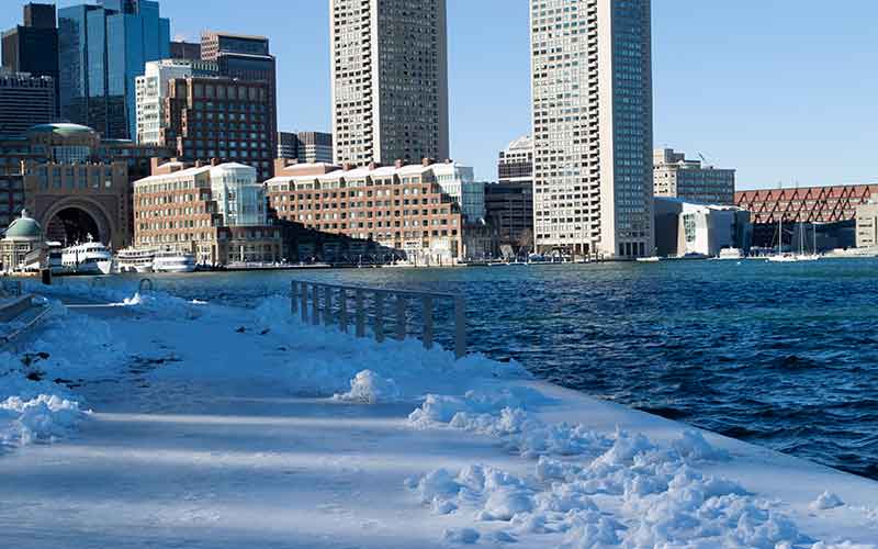
Waterfront parks and open spaces, including parts of the iconic Harborwalk, are already flooding during high tides and Nor’easters. Increasing sea level rise, along with more frequent and intense storms, threatens to inundate many of these areas for good. Everyone has the right to access and use the waterfront, but unchecked development along Boston’s waterfront and throughout the state is already encroaching on these rights. Now, climate change could undercut the public’s ability to access and use the waterfront altogether.
There is a solution, however. By making key changes to the regulations that govern waterfront development and protect our right to public access, the State can safeguard public access along the waterfront.
These are the conclusions of an analysis just released by CLF entitled “Climate Change and the Massachusetts Public Waterfront Act,” which looks at both the challenges and opportunities facing the Commonwealth’s Waterways Program.
With climate change already bringing more extreme weather to our shores, this analysis is yet another reminder that elected officials and other stakeholders need to act more urgently to address the coming crisis.
A Sobering Challenge
To understand what could happen – how climate change could impact public open space and, more importantly, the continued viability of legally required public access – we assessed future flood risks of lands within Public Waterfront Act jurisdiction. (Under the Public Waterfront Act, tidelands – land or tidal flats that are now or ever were in the past located below the high water mark – are public trust resources. The State must approve private uses of tidelands through a waterways license or permit, which lays out specific conditions and requirements for the site, including for public access.)
We collected data on 62 sites with “mappable open space” in the Seaport District, the North End, Fort Point, Charlestown, Downtown, East Boston, Dorchester, Fenway/Kenmore, South Boston, West End, and Mattapan neighborhoods. We looked specifically at flood impacts based on several estimates of sea level rise: 9 inches, which is expected to occur in the near term between 2030 and 2050; 21 inches, predicted between 2050 to 2100; and 36 inches, anticipated over the long term, by the 2070s or later. The results were sobering.
Of all of the sites analyzed, 61 percent are at risk of regular flooding in the near-term period. That number soars to 94 percent when looking long term. Despite these risks, fewer than 20 percent of waterways licenses for these sites mention sea level rise or flood risk.
Public Access at Long Wharf, Fan Pier, among Areas at Risk
East Boston’s open space is most at risk, with about 5 acres threatened by flooding from the average monthly high tide by the end of this century. This includes open space bordering the new luxury apartment development at the Eddy.
The Seaport District is also extremely vulnerable, with more than 13 acres of open space, including Fan Pier, in danger of flooding during a 100-year storm event by the end of the century. Older waterfront areas, including Prince Street Park in the North End, are not safe either. Ultimately, citywide, 1.6 million square feet, or about 37 acres, of open space will be at risk of flooding by the year 2100.
Most troubling of all? By the end of the century, we estimate that 40 percent of open space citywide will flood during the average monthly high tide. During a so-called 10-year flood, 64 percent will be under underwater. And, during a 100-year flood event, a whopping 73 percent of open space will be inundated.
What a 100-Year Flood Risk Really Means
Don’t be fooled by the terminology. A 100-year flood might sound like something that happens once a century. It actually means a flood that has a 1 percent chance of occurring every single year. Add that annual flood risk up over time, and a 100-year flood has a 26 percent chance of happening at least once in 30 years.
Climate change means these chances are going up. Across the U.S., high-tide floods happen twice as often as they did 30 years ago. Just last year, Boston experienced its highest and third-highest high tides ever recorded. Stretches of Seaport Boulevard, parts of the Harborwalk in the North End, and all of Long Wharf were underwater.
You can read more about the very real flooding risks the city faces in our report.
We Need to Light a Fire Under State and Local Leaders
The danger to our waterfront and our neighborhoods is real, and the implications are serious. It’s time for the State to address this looming threat.
So what is the solution? The Commonwealth has several options to reduce our risk and adapt. They include:
- Clarifying or revising definitions within the waterways regulations to better address climate change and its related impacts within the framework of the Public Waterfront Act.
- Encouraging flood-control measures that improve resiliency on a neighborhood- or area-wide scale.
- Clarifying or revising certain provisions within the waterways regulations to mandate consideration of future conditions and enable adaptation within the framework of the Public Waterfront Act.
Whatever options the State chooses to pursue, it must happen soon. While studies and reports are essential for understanding climate impacts, they aren’t enough. We must begin to implement regulations and actions that will protect people, property, and our precious public resources from dangerous flooding and damage. Now that we know the scope of the challenge, let’s get to work addressing it.


